Small Point Harbor
The chart shows Small Point Harbor lying to the west and north of Cape Small between Hermit and Wood Island. This would be a very uncomfortable place to spend the night. As one local put it, the chart might as well label it “Open Ocean.” A “Harbor” it may be, but certainly not a recommended one.
The real harbor at Small Point is Cape Small Harbor. In fact, this is the harbor the locals call Small Point Harbor. The harbor is an interesting little hideaway tucked between Hermit Island and the mainland. It is extremely well protected but difficult to enter—not a place to visit casually or to try to enter on a dark and stormy night. In difficult conditions, it would be far safer to make for easily entered Sebasco Harbor or The Basin, a short way north.
Cape Small Harbor is relatively undeveloped, though packed tightly with a mixture of commercial craft and pleasure boats. Blue herons pose silently along the tree-lined shores at low tide, side by side snowy egrets and other shore birds.
Approaches.
Anchorages, Moorings.
For the Boat.
For the Crew.
Approaches
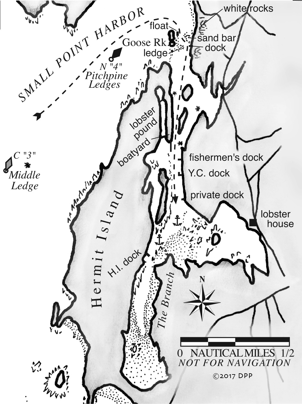
Cape Small Harbor is guarded by two overlapping bars, one of sand and the other of mussels and ledge. The approach depends on the state of the tide, and it is complicated by the inadequate scale of the chart.
Run toward the harbor along Hermit Island. Keep nun “4,” on Pitchpine Ledges, to starboard and head for Goose Rock, which at a distance seems to merge with the mainland. As you draw near, you will begin to see a narrow channel east of it. The chart shows the channel being marked by nun “2.” It isn’t.
A long, sandy beach curves south from Flat Point ending in an outcropping of white rocks. This is followed by a shorter sand beach and a second set of white rocks, which mark the beginning of the channel obstructions.
First, a sandbar extends westward from the rocks on the mainland. Then, a short distance farther south, a large rock ledge and mussel bed protrudes eastward from the southeastern end of Goose Rock. At mean low water, the channel around these bars is about 30 feet wide and about 4.5-feet deep.
John Gardner, captain of the charter boat Yankee, navigates this passage daily. He describes the approach as follows: Begin by turning southward, favoring Goose Rock to starboard. A fleet of small boats is moored in a line off the eastern shore. The center of the channel is about 30 feet to the west of those moorings. On the western shore, off Goose Rock, a float is moored for dry sailing a fleet of Optimists. The channel is about 40 feet to the left of this float.
Once abreast of the Optimist float, begin to steer eastward, to the left, toward the center of a dock projecting from the mainland shore. Stay on the line between the Opti float and the mainland dock. When you are about 10 feet off the dock, turn to the right, parallel to the dock and run straight to clear the second ledge-and-mussel bar off Goose Island.
Once past the bars, stay to the eastern side. Pass Mill Point to starboard and the two islets to port. Opposite the first islet, a ledge extends halfway across the channel from the west side—shown on the chart as an asterisk—so keep to the east, tight against the islands. From there, head straight into the harbor. There is deep water near the lobster docks on the west side of the channel. Go slowly right up the middle among the moored boats.
Anchorages, Moorings
Watch your depthsounder carefully and know the state of the tide before you drop the hook. Anchor among the moored boats if there is room or just beyond them opposite the tip of Tennants Island, in the mud bottom in 6 to 8 feet of water at low. Note that the channel curves west after Tennants Island into The Branch, and then it shoals.
The anchorage appears to be a wide open pond at high tide, but at low it becomes a narrow slot lined with clam flats and mussel beds. The prevailing southwest wind funnels down The Branch and usually keeps you lined up with the channel. But any shift in wind or surge of incoming tide can put you into the mud. You might sleep better with a stern anchor out.
One local resident says that there can be as many as eight or nine transients here on a given night, but that’s about the limit.
MHermit Island Campground, privately owned, sometimes has a mooring available, or Dspace alongside the floats extending south from the lobster pound. It is best to call ahead (443-2101).
Getting Ashore. Depending on your goal, take your dinghy either to the Small Point Yacht Club float or to the Hermit Island dock.
For the Boat
Gas and diesel are available at the floats of the lobster dock.
Robert Stevens Boatbuilders (207-389-1794). If you need any woodwork repaired or replaced, Robert Stevens can take care of you in his idyllic little yard. This is where he built a replica Viking ship, which voyaged from Greenland to Newfoundland. His next historical project is a replica of the first ship built in Maine, the Virginia of Popham.
The Small Point Yacht Club has a float just south of the obvious fishermen’s dock on the east side of the channel. You will search in vain for a clubhouse. No boat larger than 12 feet is allowed to stay on the float. The next float to the south is private.
For the Crew
If you are hungry, land at the yacht club float, scramble up the hill to the paved road, and walk right about half a mile to the main road, Route 216. Turn right, and it’s a quarter mile to the Lobster House (389-1596, closed Mon.), featuring fish and lobsters without the frills. About an hour either side of high tide you can reach the Lobster House in the dinghy by heading east from the southern tip of Tennants Island. At other times, you might be stranded.
The campground’s snack bar is at the Kelp Shed, across the sandy road on Head Beach. Their store has a snack counter and is well stocked with food and essentials.
Things to Do
For a great leg-stretching walk with a spectacular reward, head north for about a mile on Rt. 216. Take a right on Morse Mountain Road and hike another couple of miles to expansive Seawall Beach, with views of the open ocean and Seguin offshore. The beach is an Audubon sanctuary for the least tern.
The lobster pound next to the Stevens boatyard claims to be the southernmost lobster pound in Maine. You can walk across a wonderful wooden footbridge that spans the mouth of the pound, where lobsters are stocked in the fall to even out market fluctuations in late winter and early spring. The pound keeper gambles that the “hoped for” price will be well above the “going in” price. This pound will hold 40,000 to 80,000 pounds depending, as a small sign puts it, “on the state of the owner’s ulcer.”
The Hermit Island Campground dock lies up The Branch. From there or from the boatyard, walk to the entrance of the campground, right at Head Beach. But don’t walk your dog; they are not allowed. Hermit Island Campground (443-2101) has been owned and operated by the Sewall family since 1953. Pick up an island map and the schedule of naturalist talks at the Kelp Shed. Numerous trails lead all over the island, from one pocket beach to another and along stunning cliffs where the sunset spills out of the sky.