Harraseeket River
Tidal Harraseeket River creates a splendid, well-protected harbor at the north corner of Casco Bay, in the small village of South Freeport. This major yachting center has almost every facility, yet it remains simple and attractive. The fabled L.L.Bean store and an abundance of outlet shopping is close by in Freeport.
This area has a long shipbuilding history, one that parallels the history of the whole coast of Maine. Boats have been built on the Harraseeket River for two-and-a-half centuries, ever since the first settlers cut pine in the virgin forests to build England’s Royal Navy. One of the most famous, the Dash, built at the Porter Yard in 1813 at the beginning of the war of 1812, was immortalized in Whittier’s poem, The Dead Ship of Harpswell. Ships of 300 to 400 tons were built at what is now Brewer’s South Freeport Marine, and forty percent of the men in Freeport were employed by the yard. Since then, this location has seen boatyards come and go, but some of the pilings and stone abutments at Brewer’s South Freeport Marine still date from the mid-19th century.
The papers which separated the State of Maine from the Commonwealth of Massachusetts and admitted Maine to the Union were signed in 1820 at the Jameson Tavern, which still stands next to L.L.Bean.
Approaches
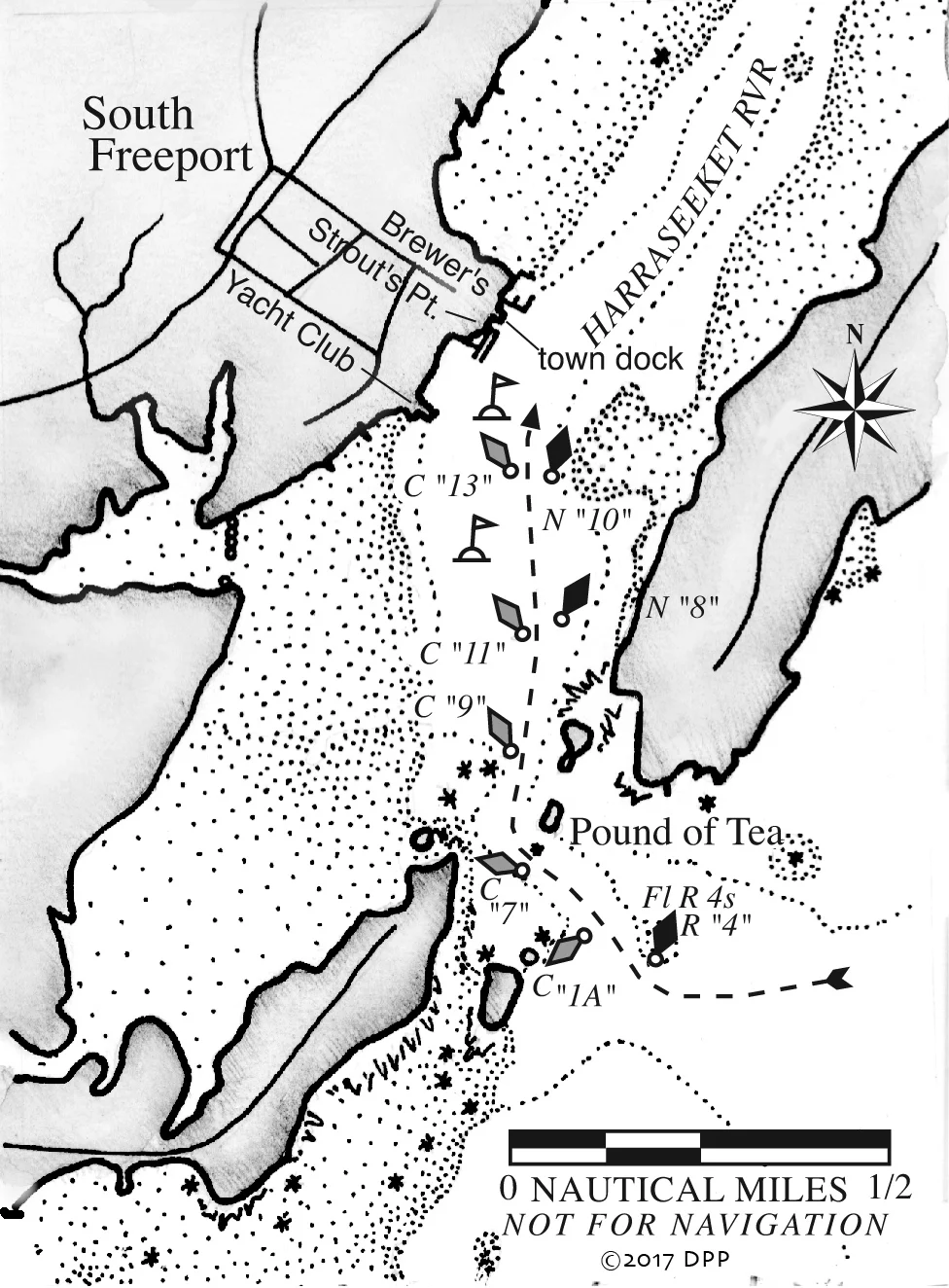
The entrance to the Harraseeket River is narrow. It bends sharply right, the current is usually strong, and the inadequate scale of the chart doesn’t inspire much confidence. In thick weather, this can be a tricky entrance for a stranger.
Starts at Little Bustins Island, pick up can “1,” and steer between Crab Island and nun “2” off Googins Ledge. Note the line of mudflats on the left, from Moshier Island to the entrance. Crab Island is almost on the edge of these flats, so leave it well to port.
There are two good landmarks for the entrance itself—tiny Pound of Tea Island with its single house and a few trees (yes, that was the original purchase price from the Indians), and The Castle, which stands high on the shore in South Freeport and shows as a tower on the chart. Leave flashing red buoy “4” to starboard and hug the left side of the channel, particularly at can “7.” The rocks making out southward from Pound of Tea are covered with bottom paint. After leaving can “7” close aboard to port, curve gradually to starboard around Pound of Tea, leaving can “9” also to port. Local boats take great joy in passing inside Pound of Tea Island, especially at high tide. Resist the temptation.
A deep and fairly narrow channel leads through several more town-maintained nun-and-can pairs to the marinas. Do not stray from this channel, and do not go where there are no moored boats. At high tide, the Harraseeket River looks like an enormous quiet lake; at low, it looks like clam flats.
Anchorages, Moorings
The first dock on the left belongs to the Harraseeket Yacht Club. There is a gap after the yacht club, and then the remaining facilities and docks are all cheek-by-jowl. First are the floats and fuel dock of Strouts Point Wharf. The town docks and public landing are next, recognizable by the red buildings of Harraseeket Lunch and Lobster nearby. The slips and fuel docks of Brewer’s South Freeport Marine are the farthest to the north.
The yacht club has one guest mooring for boats to 40 feet from reciprocal clubs. Both Strouts Point and Brewer’s South Freeport Marine have rental moorings in this crowded harbor, or they can put you on their docks. There is no room to anchor.
It doesn’t really matter where you are in the harbor, and when it is busy, you probably won’t have much choice. The protection is best and there is the least wake north of the docks, but on a mooring near the entrance you’ll have a good view of The Castle, hear the cows mooing on Wolf Neck, and see a constant and ever-changing parade of interesting boats, splashing fish, and occasional seals.
Getting Ashore Dinghy ashore to any of the floats, or hail the Brewer’s launch.
For the Boat
Harraseeket Yacht Club (207-865-4949; hyc.cc). This is an informal and friendly place whose burgee carries a drawing of The Castle. To assist visiting yachtsmen, members who are off cruising post notices on the bulletin board giving the locations of their moorings. There is no launch and no one visibly in charge, so ask a sailing instructor or a member for help or advice. Water, but not fuel, is available at the floats, with 10 feet alongside.
Strouts Point Wharf Company (Ch. 09, 16; 207-865-3899; stroutspoint.com). This boat yard and marina has moorings and slips with 8 feet alongside at low. Gas, diesel, water, electricity, and holding tank pump-outs are available as well as ice and showers ashore. Their marine store is in the wonderfully-designed little building by the docks. Specializing in classic boat restoration and repair, they haul with a 25-ton boatlift and can perform repairs of all kinds.
Town Landing (Harbormaster Jay Pinkham: Ch. 09; 207-865-4546). Thirty-minute docking is allowed on the town floats, next to the harbormaster’s office.
Brewer’s South Freeport Marine (Ch. 09, 16; 207-865-3181; byy.com/bsf). Transient slips and moorings are available by reservation. Brewer’s pumps gas, diesel, and water and provides launch service, pump-outs, electricity, ice, showers, and a laundry machine and dryer. They can handle boat repairs of all kinds.
North Sails Maine (207-865-2100). This loft is located at Brewer’s. They can fit you with a new suit or keep your old set pulling.
Falls Point Marine (207-865-4567; fallspoint.com) is located upriver at Porters Landing. Carter Becker is an ace rigger with a boat-based mast crane that can come to your boat. He also offers dive services, custom fabrications, and can help you ground out your boat at the town pier for quick bottom repairs.
For the Crew
Harraseeket Lunch and Lobster (865-4888) provides takeout, restaurant service, and live lobsters in the red building across the street from Brewer’s, but you’ll need to BYOB.
For groceries and liquor, you might be able to get a ride to the Bow Street Market (865-6631) or Shaw’s (865-0094) about three miles away in Freeport. The Freeport Taxi is at 865-9494.
Things to Do
If you have been repressing your consumer urges all this time on the boat, don’t miss L.L.Bean, open 24 hours a day in Freeport. Attracted by the store’s popularity, more than 80 other stores, factory outlets, and boutiques now cluster in the town.
Casco Castle was a large Victorian hotel built around the turn of the century by Amos Gerald, the “Electric Railway King.” The Castle is now private, with a new house built on the property, but wonderful photos of The Castle and early South Freeport can be seen at the small post office. Gerald had built an electric trolley which ran from Brunswick to Yarmouth and brought guests to the hotel. The trolley was completed in 1904, but the hotel burned in 1914, leaving only the stone tower. The trolley was discontinued in 1927.
Within 2 or 3 hours of high tide when water covers the mud, take your dinghy up the estuary at the northeast end of the harbor to Mast Landing, named for the enormous pines felled and shipped to England for masts. Just beyond is Mast Landing Sanctuary, operated by Maine Audubon, with trails and nature exhibits.
Or explore the trails of Wolfe’s Neck Woods State Park on the eastern side of the river. To get there, take your dinghy ashore at one of the two little indentations shown on the chart to the right of the word “Harraseeket.” Be sure to leave before the tide strands you on the mudflats.